Thursday, February 7, 2013

Back in Bangladesh


We're back in Bangladesh now. We're spending the week exploring more anticlines (folds) and meeting with our colleagues who study the rivers. Today we got to see tube well drilling.

There's a special drilling technique they use in Bangladesh. One member of the drill team uses their hand as a valve, just like you might use your finger to keep suction to lift water up in a drinking straw. Three or four other guys pull on a lever to lift the drill pipe up. They can drill really deep!
Each time the pipe drops down, a squirt of sand, mud and water comes out the top. They catch some in a bucket and then they can study its composition and see how it changes as they dig deeper. 

Our colleague Professor Goodbred has an awesome tool called the XRF. It stands for X-ray Fluorescence. It shoots x-rays at a sample of sand and measures different elements. The chemistry can tell us where the sand came from! This helps us learn about where the rivers were in the past. We work with scientists who study rivers because rising mountains and earthquakes can cause the rivers to change course!


 We've been having a little bit of trouble in Bangladesh because they've had some political strikes called hartals. During a hartal, cars can't drive around because people set up road blocks and may attack cars. During the 48 hour hartal, we needed to work so we had to take a truck on the dirt road through a national park. It was a bumpy ride. We didn't see any angry mobs. It was very peaceful and we even saw a monkey with a baby!


Faults and earthquakes!

At a rock outcrop, the main things we look for are bedding planes (that were originally flat) and faults. Faults are cracks in the rock where the rocks have moved. Huge faults can produce huge earthquakes. Little faults can help us learn about tectonic forces and buried faults that we can't access.

We were really excited to find some big faults on this trip in India. These faults cut through basalt, which is a really hard igneous rock. Igneous rock forms from magma or lava instead of sand and mud.

This fault had a layer of crushed up rock almost three feet thick. We were able to climb inside the fault zone to take our measurements!

There are three main kinds of faults: normal, reverse and strike-slip. Normal faults happen when plate tectonic forces pull apart and reverse faults happen when the forces push together. Strike-slip faults are where plates move past each other, like the San Andreas fault in California. The main fault I'm studying is a kind of reverse fault and the tectonic forces push one plate over the other.

Sometimes it can be hard to figure out which kind of fault you're looking at, so I have to make careful observations (even if that means climbing into the fault zone!)


On January 9th there was an earthquake nearby, but we didn't feel it. It was an interesting earthquake because it was really deep and east of the Dauki fault that I'm studying. Maybe the Dauki fault continues farther than everyone thought!
Here's a link to a summary of the earthquake (it has a map so you can see the earthquake location):
http://earthquake.usgs.gov/earthquakes/eventpage/usc000elmf#summary

Tuesday, February 5, 2013

Detective work


Geologists are like detectives. We are trying to piece together the story of how and when the rocks formed and how and when they have moved. Every rock has a story to tell about the environment when it formed. The rocks in these mountains also tell the history of motion on faults underground.


In answer to Dayleni Grullon’s question, one of the rocks we study in this part of India is limestone. You may remember that I passed a piece of it around the classroom back in September. The limestone is made from the shells of creatures that lived in shallow ocean water. We can figure out when the limestone formed because it has fossils of animals that went extinct. So the rock told us that there used to be an ocean here X million years ago, before the mountains formed!

Next I try to figure out what story rocks can tell us about plate tectonics. I use my special compass to measure how the sedimentary rocks have tilted and I make a map. My map tells us which way the rocks have folded and that tells us which way they’re being pushed by plate tectonics.


Limestone is also really cool because it can be dissolved and form caves. We found and explored a cave in India! We found stalagtites that have been tilted, and my friend Chris is going to measure how old they are so we can estimate how fast they are being tilted. He’s also going to measure the age of broken stalagtites to try to figure out when ancient earthquakes happened so we can estimate the repeat time of earthquakes here. The cave was a little bit scary – I saw a HUGE spider! (that's Professor Seeber's hand. He's braver -- or perhaps more foolish? -- than I)


Luis Tapia asked how rocks are folded, which is a really great question. Sedimentary rocks are formed in horizontal (flat) layers. When plate tectonic forces push on rocks, they bend and break. When rocks bend the layers become curved and that’s what we call a fold. When the rocks break a fault is formed and that’s where earthquakes happen.

Here's a dramatic photo of folded rock I borrowed from someone else's geology blog so that you can see a really clear example. (http://www.itsasickness.com/geology/content/folded-rock)


I really enjoyed reading all your questions and comments, thanks for all the great ideas for new blog posts! Here's a brief food update:
I was served rice in a banana leaf last week, and yesterday we got to have pineapple for dessert!


Sunday, January 27, 2013

Animals in the field


When you think about India and Bangladesh, you probably imagine lots of elephants, tigers, rhinos, monkeys and poisonous snakes. On my first visit, I thought I would encounter exotic animals but I saw none. These animals are endangered and their remaining populations are confined to national parks, nature reserves and rescue centers.

So what sort of animals have I seen during my fieldwork?

On this trip, I have seen scorpions, lizards, monkeys, spiders, livestock, fish and lots and lots of dogs. 

We collected a rock sample right next to this scorpion. Luckily he didn't move because it was a cold morning.


We saw one dog with 11 puppies! Cows, chickens and goats roam around freely and Suren (our driver) often has to honk to get them to move out of the road. 


We have also seen a lot of water buffalo that are used to pull carts.


We did some fieldwork near a monkey rescue center here in Meghalaya, India. The Western Hoolock Gibbon is an endangered species native to this area so they breed and release Gibbons here. They also rescue other monkeys that have been illegally kept as pets. They currently have Gibbons named Remi and Robinson.


I saw this wild monkey up on an outcrop while we were working in Assam, India. Sadly, his habitat was being destroyed to make way for construction. There are so many people here in Bangladesh and India that there aren’t many undisturbed places for wild animals to live anymore. 

Monday, January 21, 2013

Trip through Tripura

I apologize for the delay in posting, we have been without internet access. Here's a post I wrote last week for you!


I spent the past week working my way across the Indian state of Tripura with Professor Seeber and students named Jonathan and Fayaz. Our very skilled driver, Suren, has been keeping us safe on challenging roads. We visited a series of big hills formed by rock that has been folded up into anticlines. We hop in and out of the car to make measurements on rock outcrops and to collect samples. When we find a quarry, we spend lots of time walking around measuring faults and rock layers.


It has been very foggy and chilly in the mornings. We have enjoyed delicious breakfasts of parata (flat bread), dal (lentils), ‘momlet’ (eggs), and cha (tea). It really hits the spot on a cold morning!

We’ve observed lots of exciting features including really tight folds in the rocks, rock bedding that has been tilted from horizontal to vertical, and fossil wood!


We visited the Unakoti archeological site where giant figures were carved into a nearly vertical bed of sandstone during the 9th-12th centuries. I even managed to find a place to measure the rock angle – right below large figures of Ganesha!


I have been working 7 days a week from about 6:30am until the sun sets around 5pm, but don’t worry we’re having fun and lots of adventure! I even got to try playing cricket with some middle schoolers during lunch one day.


Tuesday, January 8, 2013

Greetings from Bangladesh!


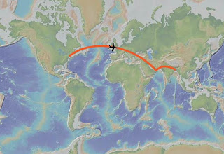
We left JFK for Dhaka, Bangladesh on the morning of January 3rd and arrived in the evening on January 4th. There is an 11-hour time difference between Bangladesh and New York, so while you’re at school I am eating dinner, writing to you and sleeping because it’s night here!

On the first day here, we drove from Dhaka to a place called Sitakund in the southeastern part of Bangladesh. The main bridge across the Meghna River is closed for construction so traffic was even worse than usual! We thought we would have to drive 50 miles north to reach another bridge, but our amazing driver called his friend and found out about a little-known ferryboat. It saved us many hours and we enjoyed our trip across the river.
The ferryboat is a barge that carries cars back and forth across the river. We saw lots of fishing boats on the river. The weather has been nice but some days there has been a lot of haze in the air.
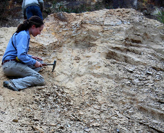
 We are in Sitakund because the rocks are folded, in what we geologists call an “anticline.” The sedimentary rocks here are made of layers of sand and mud that were originally deposited horizontal. Now those layers have been folded upwards due plate tectonic forces. The rock is crumpling up like a rug being pushed at from one end.
Our team at Sitakund: Jonathan, Suvro, Professor McHugh, Sojan, Fayaz, Professor Seeber, Dhiman and Ms. Ferguson.


I’m having a lot of fun hiking around this hill taking measurements. It is beautiful! We’re trying to determine the geometry of faults hidden below the surface here by mapping the folded rock. We also collect pieces of rock to study in the lab when we get home.


Soon Jonathan, Professor Seeber, Fayaz and I leave Bangladesh for India, where we will be crossing more anticlines. Studying these folds and the faults beneath them is very important for understanding how this plate tectonic boundary works and determining the earthquake hazard.


 This map shows the eastern border of Bangladesh in yellow. The green stripes are anticlines (some have their names written on top). They are green because they are hills with trees on top. We will be working on many of the anticlines as we cross Tripura, India. The ground is being crumpled like a rug, forming many folds. 

I hope I will have internet access again soon and I look forward to reading your questions and comments!

Monday, December 17, 2012

Preparing for Fieldwork!

Welcome to my fieldwork blog! I'm a grad student at Columbia University, and I get to spend Tuesdays with the 8th graders at the Washington Heights Expeditionary Learning School. I will use this blog to keep in touch with these all-star students while I'm in the field.

Bangladesh is the most densely populated country in the world, and there's a fault along the northern border that may have produced huge earthquakes in the past. By collecting data and observations about this fault, we can improve our understanding of how it deforms, how long it has been active and what sort of destruction it can cause.

On January 3rd I depart for five weeks of fieldwork in Bangladesh and India.
I hope you'll follow along as I explore the geology of Bangladesh and eastern India!


Please add your questions in the comment section to help inspire my future blog posts!